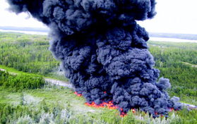
July 2002: Enbridge 34-inch diameter steel pipeline ruptured in a marsh west of Cohasset, Minnesota. To prevent 6,000 barrels (252,000 gallons) of crude oil from reaching the Mississippi River, the company set the oil on fire. The plume of smoke extended one mile high. The U.S. National Transportation Safety Board blamed the rupture on “inadequate loading of the pipe for transportation.”
potential impacts to hubbard county water resources
The following information and links show the potential impacts of Enbridge's Line 3 route to our county. The Fishhook River Chain of Lakes map shows where a pipeline leak in Hay Creek poses a direct, imminent and potentially irreversible level of damage to the water quality in the chain. Other lakes in Hubbard County could be affected as well. The following article by Nate Bowe of the Detroit Lakes Newspapers, reprinted in Wed 10/8/14 Park Rapids Enterprise and used with permission - Former officials blast Sandpiper (& Line 3) as worst possible route explains the aquifer and groundwater danger of contamination for the city water supply of Park Rapids, local industries, irrigated agricultural crops, the Straight River trout stream, and potentially lakes like Long and Hines. Merritt’s aerial chart depicts the wells at risk as discussed in the article. Lakes close to the Enbridge-proposed route alternatives include Upper Twin Lake, Duck, and Palmer in Hubbard County. All county property owners would be affected by a required upward adjustment to the tax rate to offset a decline in value of properties directly impacted by a spill. See excerpt from a letter published in the Park Rapids Enterprise by a member of FOH which analyses the potential county-wide economic impacts of a spill.